Paris Metro Map
Use the Paris Metro Map below to find all 16 Metro lines and 5 RER lines, stations and connections across Paris. Click the map to open a larger version.
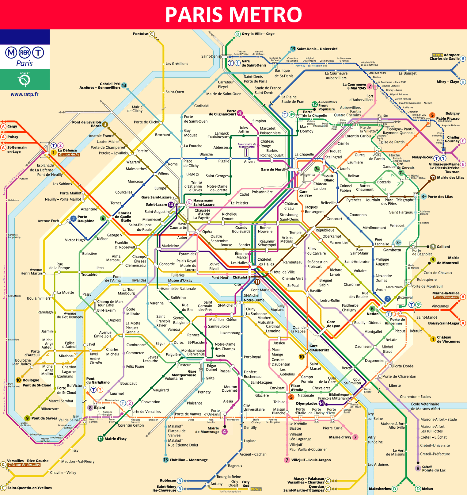
Paris Metro Map showing the 16 Metro lines and 5 RER lines of Paris.
How to Use the Paris Metro and RER System
The Paris Metro and RER network is one of the largest public transport systems in Europe. It allows you to travel quickly between tourist attractions, train stations and airports such as Charles de Gaulle and Orly.
- 16 Metro lines covering Paris and nearby suburbs
- 5 RER lines connecting Paris with the suburbs, airports and Disneyland Paris
- Easy access to major attractions including the Eiffel Tower, Louvre Museum and Champs-Élysées
Understanding how the Metro and RER lines connect makes travelling around Paris much easier. The individual line maps and guides below provide routes, stations and useful information for each line.
Paris Metro Tickets and Travel Tips
Paris offers several ticket and travel pass options for Metro and RER journeys. The best choice depends on how long you are staying, how often you plan to use public transport and whether you need to travel to the airports or outer zones.
Compare Paris Metro tickets and passes for your stay →
Paris RER Lines
RER A
Cergy Le Haut / Poissy / Saint-Germain-en-Laye – Marne-la-Vallée Chessy / Boissy-Saint-Léger
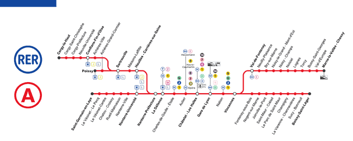
Paris RER A map
RER A serves Disneyland Paris, the Champs-Élysées and the Arc de Triomphe. It connects Saint-Germain-en-Laye, Cergy and Poissy in the west with Boissy-Saint-Léger and Marne-la-Vallée in the east through central Paris.
Read more about RER A
RER B
Saint-Rémy-lès-Chevreuse / Robinson – Aéroport Charles de Gaulle / Mitry-Claye
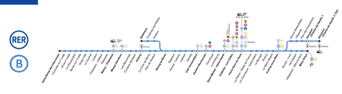
Paris RER B map
RER B provides a direct rail connection between Charles de Gaulle Airport and central Paris. It serves major stations including Gare du Nord, Châtelet–Les Halles and Saint-Michel–Notre-Dame.
Read more about RER B
RER C
Versailles Château / Pontoise / Saint-Quentin-en-Yvelines – Dourdan / Saint-Martin-d’Étampes
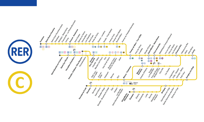
Paris RER C map
RER C is useful for visitors travelling to the Eiffel Tower and the Palace of Versailles. It crosses Paris while connecting the city with several destinations in the western and southern suburbs.
Read more about RER C
RER D
Creil – Melun
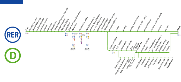
Paris RER D map
RER D crosses central Paris and serves major transport hubs including Gare du Nord, Châtelet–Les Halles and Gare de Lyon. It also provides access to the Stade de France area via connections in Saint-Denis.
Read more about RER D
RER E
Western Paris / La Défense – Chelles-Gournay / Tournan
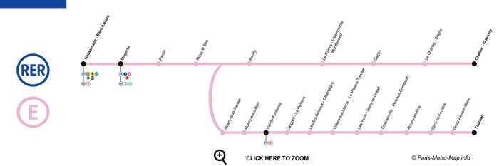
Paris RER E map
RER E crosses the Paris region from east to west and serves major business and transport areas including Saint-Lazare and La Défense.
Read more about RER E
Paris RER Map
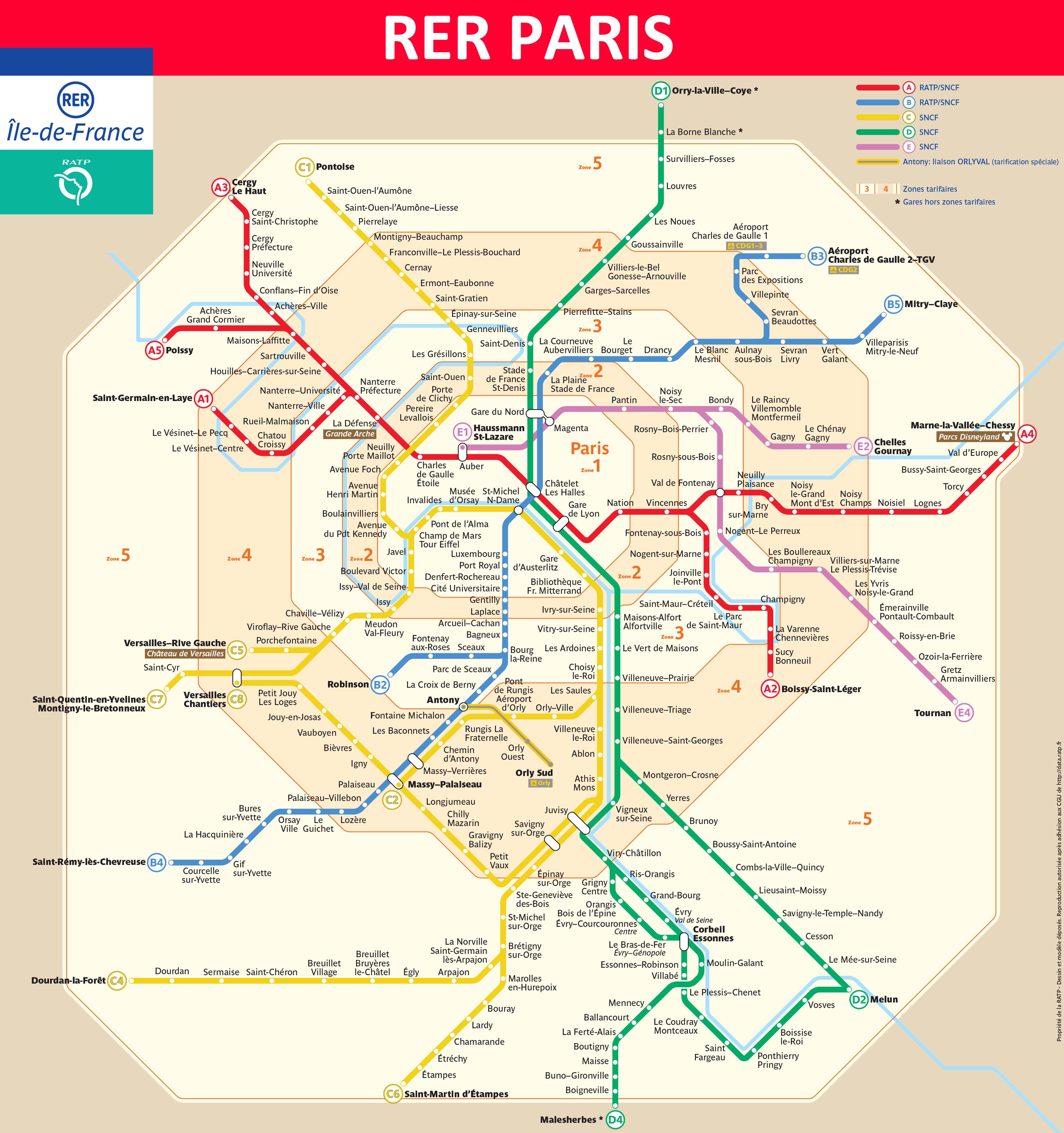
Paris RER map
Paris Metro Lines
The Paris Metro network has 16 lines, numbered 1 to 14 plus Lines 3 bis and 7 bis. Select a line below to see its map, route, stations and connections.
Paris Metro Line 1
La Défense – Château de Vincennes
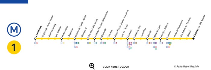
Paris Metro Line 1 map
Line 1 crosses Paris from west to east and serves major destinations including La Défense, the Champs-Élysées and the Louvre.
More information about Paris Metro Line 1
Paris Metro Line 2
Porte Dauphine – Nation
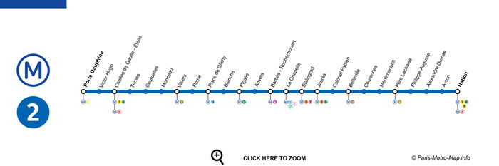
Paris Metro Line 2 map
Line 2 crosses northern Paris between Porte Dauphine and Nation, serving areas including Pigalle and Montmartre.
More information about Paris Metro Line 2
Paris Metro Line 3
Pont de Levallois–Bécon – Gallieni
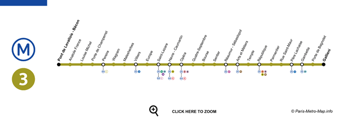
Paris Metro Line 3 map
Line 3 connects western and eastern Paris and serves destinations including Opéra and Père Lachaise.
More information about Paris Metro Line 3
Paris Metro Line 3 bis
Gambetta – Porte des Lilas
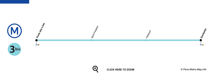
Paris Metro Line 3 bis map
Line 3 bis is one of the shortest lines on the Paris Metro network and operates between Gambetta and Porte des Lilas.
More information about Paris Metro Line 3 bis
Paris Metro Line 4
Porte de Clignancourt – Bagneux–Lucie Aubrac
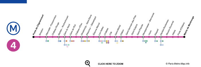
Paris Metro Line 4 map
Line 4 crosses Paris from north to south and serves major railway stations including Gare du Nord, Gare de l’Est and Montparnasse.
More information about Paris Metro Line 4
Paris Metro Line 5
Bobigny–Pablo Picasso – Place d’Italie
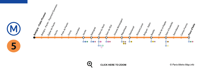
Paris Metro Line 5 map
Line 5 serves eastern and northeastern Paris and connects several major railway and Metro stations.
More information about Paris Metro Line 5
Paris Metro Line 6
Charles de Gaulle–Étoile – Nation
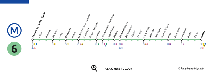
Paris Metro Line 6 map
Line 6 crosses southern Paris between Charles de Gaulle–Étoile and Nation. Part of the route runs above ground and offers views of the Eiffel Tower.
More information about Paris Metro Line 6
Paris Metro Line 7
La Courneuve–8 Mai 1945 – Villejuif–Louis Aragon / Mairie d’Ivry
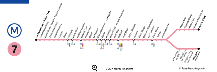
Paris Metro Line 7 map
Line 7 connects northeastern Paris with Villejuif and Ivry in the south and serves central Paris, including the Louvre area.
More information about Paris Metro Line 7
Paris Metro Line 7 bis
Louis Blanc – Pré-Saint-Gervais
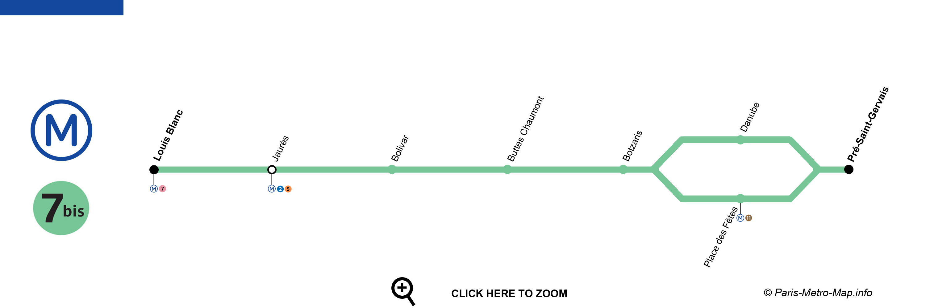
Paris Metro Line 7 bis map
Line 7 bis is one of the shortest lines on the network and serves northeastern Paris.
More information about Paris Metro Line 7 bis
Paris Metro Line 8
Balard – Pointe du Lac
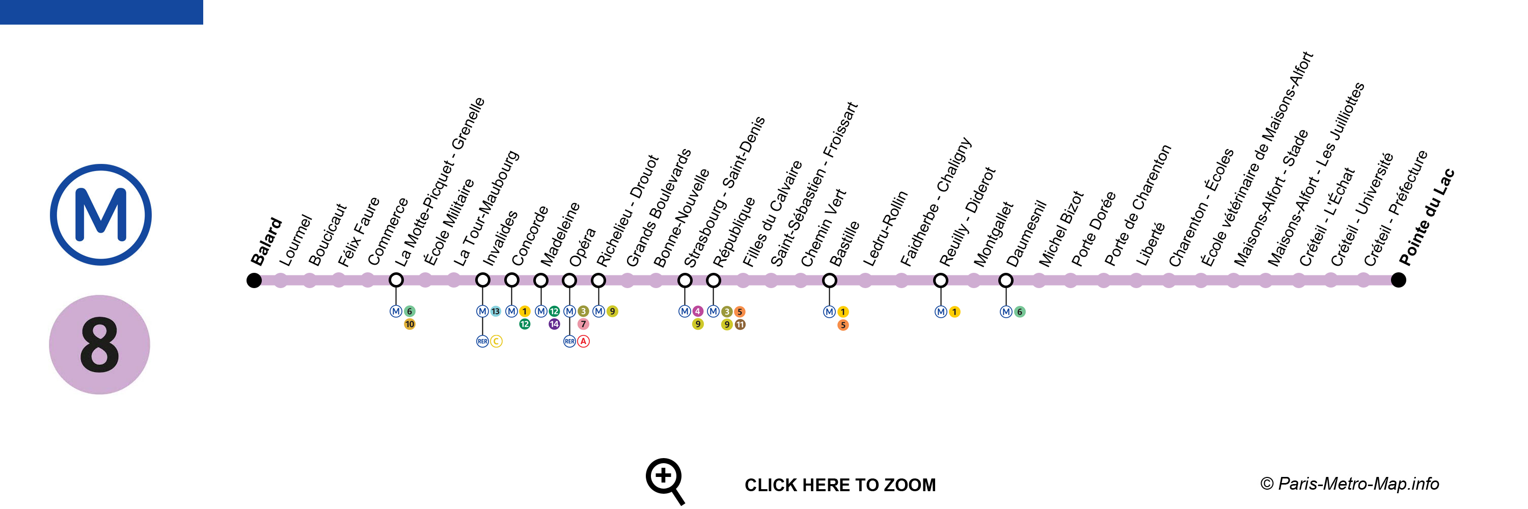
Paris Metro Line 8 map
Line 8 connects southwestern Paris with Créteil and serves central locations including Concorde and Opéra.
More information about Paris Metro Line 8
Paris Metro Line 9
Pont de Sèvres – Mairie de Montreuil
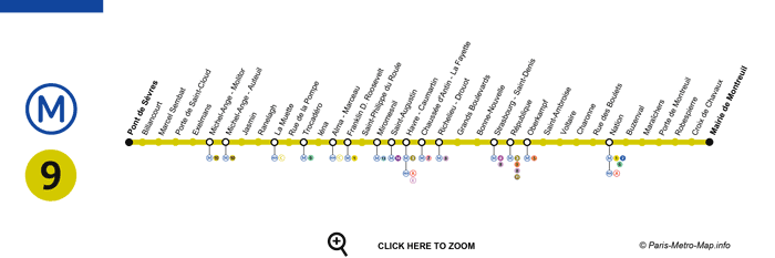
Paris Metro Line 9 map
Line 9 crosses Paris from Boulogne-Billancourt to Montreuil and serves areas near the Eiffel Tower and Champs-Élysées.
More information about Paris Metro Line 9
Paris Metro Line 10
Boulogne–Pont de Saint-Cloud – Gare d’Austerlitz
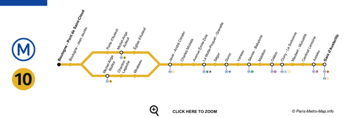
Paris Metro Line 10 map
Line 10 connects Boulogne-Billancourt with Gare d’Austerlitz through western and central Paris.
More information about Paris Metro Line 10
Paris Metro Line 11
Châtelet – Rosny–Bois-Perrier
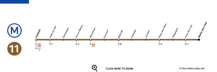
Paris Metro Line 11 map
Line 11 connects Châtelet in central Paris with Rosny–Bois-Perrier in the eastern suburbs.
More information about Paris Metro Line 11
Paris Metro Line 12
Mairie d’Aubervilliers – Mairie d’Issy
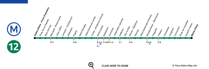
Paris Metro Line 12 map
Line 12 crosses Paris from Aubervilliers to Issy-les-Moulineaux and serves popular areas including Montmartre, Pigalle and Concorde.
More information about Paris Metro Line 12
Paris Metro Line 13
Asnières–Gennevilliers–Les Courtilles / Saint-Denis–Université – Châtillon–Montrouge
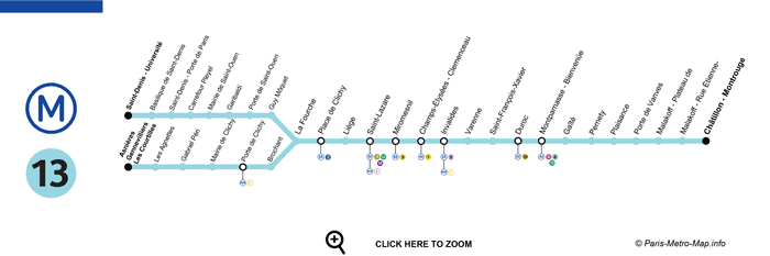
Paris Metro Line 13 map
Line 13 connects the northern and southern suburbs through Paris and serves areas including Saint-Lazare, Champs-Élysées and Invalides.
More information about Paris Metro Line 13
Paris Metro Line 14
Saint-Denis–Pleyel – Orly Airport
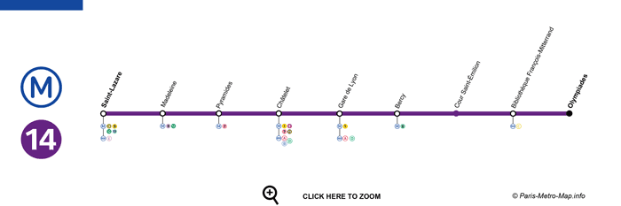
Paris Metro Line 14 map
Paris Metro Line 14 is a fully automated line running between Saint-Denis–Pleyel and Orly Airport. It serves major transport hubs including Saint-Lazare, Châtelet and Gare de Lyon and provides a direct Metro connection between central Paris and Orly.
More information about Paris Metro Line 14
FAQ – Paris Metro Map & Travel Guide
Is the Paris Metro easy to use?
Yes. The Paris Metro is relatively easy to use once you understand the line numbers and directions. Each line has a number and colour, and signs inside stations indicate the terminus you should follow.
How many Metro lines are there in Paris?
The Paris Metro network has 16 lines: Lines 1 to 14 plus Lines 3 bis and 7 bis. Together they provide extensive coverage of Paris and some nearby suburbs.
What is the difference between the Paris Metro and RER?
The Metro mainly serves Paris and nearby suburbs, with stations relatively close together. The RER covers longer distances and connects central Paris with outer suburbs and destinations such as Charles de Gaulle Airport, Disneyland Paris and Versailles.
How much is a Paris Metro ticket in 2026?
In 2026, a standard Metro-Train-RER Ticket costs €2.55 at full fare for eligible journeys on the Metro, train and RER network. Special fare rules apply when travelling to or from airport rail stations.
Can I change Metro lines with the same ticket?
Yes. You can make permitted connections between Metro lines during the same journey without buying a new ticket, provided you remain within the transport network and follow the applicable ticket conditions.
What time does the Paris Metro open?
Metro service generally begins early in the morning, but the exact first train time depends on the line, station and direction. Check the current RATP timetable if you need to travel very early.
What time does the Paris Metro close?
The time of the last Metro varies according to the line, station, direction and day of the week. Services generally run later on Friday and Saturday nights, but check the official timetable for your specific journey.
Does the Paris Metro run on Sundays?
Yes. The Paris Metro operates seven days a week, including Sundays and public holidays, although service frequency and planned works may vary.
Does the Paris Metro go to Orly Airport?
Yes. Metro Line 14 goes directly to Orly Airport and provides a convenient connection from central Paris, including stations such as Saint-Lazare, Châtelet and Gare de Lyon.
Does the Paris Metro go to Charles de Gaulle Airport?
The Metro does not run directly to Charles de Gaulle Airport. The RER B provides direct rail service between Charles de Gaulle Airport and central Paris, including Gare du Nord and Châtelet–Les Halles.
Which Metro line should I take for the Eiffel Tower?
Line 6 is particularly convenient for the Eiffel Tower. Get off at Bir-Hakeim. Trocadéro, served by Lines 6 and 9, is another popular option for views of the tower.
Which Metro station should I use for the Louvre?
Palais Royal–Musée du Louvre on Metro Lines 1 and 7 is one of the most convenient stations for the Louvre Museum. Line 14 passengers can also use Pyramides and walk towards the museum.
Which Metro line goes to the Champs-Élysées?
Metro Line 1 runs along the Champs-Élysées area, with stations including George V, Franklin D. Roosevelt and Charles de Gaulle–Étoile.
Which Metro line should I take for Montmartre?
Metro Lines 2 and 12 are useful for Montmartre. Abbesses on Line 12 is located in the heart of the neighbourhood, while Anvers on Line 2 provides convenient access towards the Sacré-Cœur.
How do I get to Disneyland Paris by train?
Take RER A towards Marne-la-Vallée–Chessy. The terminus is located next to the entrances to Disneyland Paris.
How do I get to Versailles from Paris?
The RER C is one of the most commonly used rail routes for visitors travelling from Paris towards Versailles. Check your destination and current service information before travelling, as the RER C has several branches.
Which Paris Metro line is best for sightseeing?
Line 1 is particularly useful for sightseeing because it serves or passes close to major attractions including the Louvre, Champs-Élysées, Arc de Triomphe and Tuileries. Line 6 is also popular because part of its route runs above ground near the Eiffel Tower.
Is the Paris Metro safe for tourists?
Millions of passengers use the network, but tourists should pay particular attention to their belongings in busy trains and major interchange stations. Keep phones, wallets and bags secure, especially in crowded areas.
Is the Paris Metro accessible with luggage?
You can travel on the Metro with luggage, but many older stations have stairs and limited step-free access. Line 14 is particularly convenient for travellers with luggage because its stations were designed with accessibility in mind and the line serves Orly Airport.
Is the Paris Metro wheelchair accessible?
Accessibility varies significantly across the Paris Metro network. Many older stations are not fully step-free. Line 14 is the most accessible Metro line, but travellers who depend on lifts should check the current status of station equipment before travelling.
Can I use contactless payment on the Paris Metro?
Paris public transport increasingly supports digital and contactless ticketing through compatible Navigo services and smartphones. The available options depend on your device and ticket type, so check the current ticketing options before travelling.
Should tourists buy a Navigo pass or individual Metro tickets?
It depends on the length of your stay and how frequently you plan to travel. Visitors making only a few journeys may prefer individual tickets, while frequent travellers may benefit from a pass.
Compare Paris Metro tickets and passes →
Useful Paris Transport Guides
If you are planning your trip to Paris, these guides can help you choose the best transport options:
- How to get from Paris airports to the city center
- Which Paris Metro ticket or pass should you choose?